 Kaeng Krachan National Park
Kaeng Krachan National Park was established in 1981, the 28 th National Park in Thailand. It is the largest national park in Thailand, with 1,821,875 rai (2,915 square kilometers) of forest in the watersheds of the Phetchaburi and Pranburi rivers. It includes portions of Amphur Nong Ya Plong, Amphur Kaeng Krachan, and Amphur Tha Yang in Phetchaburi Province and of Amphur Hua Hin in Prachuab Khiri Khan Province.
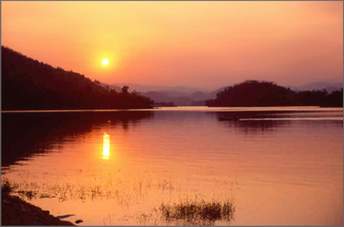
The Kaeng Krachan area includes a reservoir lake, beautifual scenery, waterfalls, caves, mountains.It is almost entirely covered with evergreen forest, which supports ecologically, economically and scientifically valuable plants and animals, including many wild elephants. The park is an excellent place for recreation and education, and it is carefully protected in accordance with the wishes of His Majesty King Bhumipol. It is an important part of Thailand's national heritage.
History
Kaeng Krachan dam, at the middle of the eastern border of the National Park, was the first earth dam ever constructed in Thailand, more than 30 years ago. Its reservoir is fed by a forested watershed which extends to the Tenasserim Crest, the mountain range dividing the watersheds of the Gulf of Siam and the Andaman Sea. His Majesty King Bhumipol Adulyadej has visited the site many times, both before and after the construction of the dam. He has always been very concerned about the conservation of this watershed area, as indicated in his speech of October 29,1979 : "In Phetchaburi watershed forest, the officers must guard against deforestation, illegal logging or cultivation, because they cause drought."
The National Park was designated on June 12,1981: its original borders encompassed 1.5 million rai. On April 20,1983, Thalemg Thamrongnawasawad, Permanent Secretary of the Ministry of Agriculture and Cooperatives, presided over the official opening ceremony. On December 27,1984, the park area was extended, as proposed by the Hua Hin Environmental Conservation Group, to cover the boundary between Phetchaburi and Prachuab Khinkhan Provinces, bringing the total area to over 1.8 million rai.
Kaen Krachan National Park map |
 |
| 1.Headquarters 2.Kaeng Krachan district 3.Kaeng Krachan dam lake 4.Panoen Thung camp (km. 30) 5.Panoen Thung peak (1207 meters) 6.Thor Thip waterfall 7.KU camp (rafting start point) 8.Petchaburi river 9.Pong Luek Karen village 10.Mhuang Kao 11.Pranburi river 12.Pa-La-U waterfall 13.Gulf of Thailand |
National Park
Kaeng Krachan is located on the eastern slope of the Tenasserim Mountain Range at the border of Burma (Myanmar). It occupies the western half of Phetchaburi Province (Amphur Kaeng Krachan and Amphur Nong Ya Plong) and a portion of northern Prachuab Khiri Khan Province (Amphur Hua Hin).
The park is compossed of two major watersheds. About half of the area drains to the Phetchaburi River, which flows to Kaeng Krachan dam at the eastern edge of the park and then down through farmland to the provincial capital of Phetchaburi. The southern half of the park drains to the Pranburi River, which flows south to the Pranburi dam and then on to the town of Pranburi in Prachuab Khiri Khan Province. Because of abundant rainfall and undisturbed forest cover in these watersheds, the streams, waterfalls and rivers of Kaeng Krachan flow year-round.
The nearest cities to the park are Phetchaburi Town, the market town of Tha Yang, and the resort cities of Cha-Am and Hun Hin. The park is located about 240 kilometers from Bangkok. Only two roads are maintained within the park. One leads to the Pala-u Waterfall in the southern part of the park; the other enters the forest 20 kilometers away from headquarters, and continues for 35 kilometers westaard into the heart of the park near Khao Panoen Thung.
The steep terrain of Kaeng Krachan makes it very difficult to travel within the forest. The rivers have cut deep valleys through sandstone to the underlying granite. Some limestone deposits occur, primarily in the Pranburi river basin. Khao Panoen Thung, at 1,207 meters, is the tallest peak entirely within the park. It is a dome of granite resistant to the erosion which has removed the sandstone around it. The highest point in the park is a peak along the Burmese border, at 1500 meters.
Humidity remains high throughout the year, with heavy rain during the rainy season and cool weather for much of the year. The steep forested areas of the park are even more humid than the young forest and cleared lands in the lower elevations; some days it is clear and warm at headquarters, but it may be raining very hard in the forest 20 kilometers away. Near headquarters, annual rainfall averages 1,100 milimeters (although within the forest, it is probably much more). The wettest month is October, when rains can be nearly continuous and almost one-quarter of the annual rainfall may arrive. The driest month in an average year is January. The coldest months are December and January; the hottest are March and April. Temperatures in the area range from 10 to 40 Degree Celsius , and may get colder on the mountaintops within the forest. Most of the park is covered in deep, steep forest, Over three-quarters of the area has slopes greater than 30%, 85% of the terrain is evergreen rainforest; another 10% is mixed deciduous forest. The forest is rich and complex, with hanging lianas, aerial ferns and orchids, and an abundance of fruiting trees and vines. The forest of Kaeng Krachan is unusually diverse because of its location at the juncture of continental Asia and the Malaysian Peninsula. Continental species such as oaks, chestnuts, and maples are found here, as are peninsular palms and fruiting trees. Some of the valuable trees of Kaeng Krachan include makhamong (Afzelia), thakhian (Hopea), jantana, yang (Dipterocarpus), tabaek (Lagerstroemia), pradoo (Pterocarpus), krisna (Aquilaria), and many more. Like the plant community, the animals of Kaeng Krachan represent both Asiatic and Jalaysian species. Over 400 species of birds are known to occur within the Park's boundaries, and 57 mammais. Larger mammals include elephant, gaur, sambar, banteng, serow, bear, tiger, leopard, both common and Fea's barking deer, tapir, white-handed gibbon, dusky and banded langurs (leaf monkeys), wild dog, otter, and wild pig. Four white elephants captured in this area have been given to His Majesty the King. Among the birds recorded in the park are six species of hombills, red junglefowl, both Kalij and grey peacock-pheasants, woolly-necked stork, black eagle, and many species of songbirds, woodpeckers, and other forest birds. The ratchet-tailed treepie, first seen here by members of the Bangkok Bird Club (Bird Conservation Society of Thailand) on an outing in 1991, has not been recorded anywhere else in Thailand.
Contact
Kaeng Krachan National Park Amphur Kaeng Krachan, Phetchaburi 76170
See Kaeng Krachan Park photos ![]() See Kaeng Krachan Park map
See Kaeng Krachan Park map ![]()
Homepage ![]() National Parks
National Parks ![]()