Prachuap Khiri Khan

Prachuap Khiri Khanicon Prachuap Khiri Khan This unpretentious and somnolent provincial capital lies 90 kilometres south of Hua Hin and nestles against a crescent bay ,with a fine beach. The most prominent landmark is a beachside hillock named Khao Chong Kra Chok (Mlirror Mountain) near the provincial office.

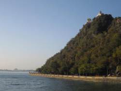
The hillock supports a Buddhist shrine on the top, which is reached by a climb of some 390 steps. A tribe of mischievous monkeys inhabit the hillock. The summit affords exhilarating views of the rugged coastline to the north. including Sam Roi Yot, and a splendid view of Ao Manao (Lemon Bay). This beautiful curved bay located on the southern edge of the town, is in the care of the Royal Thai Air Force. It was the scene of a battle between the Thais and the Japanese in World War II .

The City Pillar Of Prachuab Khiri Khan
Situated in the city centre of Prachuab Khiri Khan. the pillar is very beautiful and built in style of art from the Lop Buri period. It is known as the biggest and the most beautiful city pillar in Thailand.

Prachuab Khiri Khan Past
In Sri Ayuthaya Period Prachuab was named "Muang Bang Nang Rom" or "Muang Narang". During the Rattana Kosin Era, King Rama II moved the town to Muang Kui, When King Rama IV ascended to the throne the name was changed to "Prachuabkhirikhan" During the reign of King Rama V, encompassing Amphur Muang, Pran Buri and Kumnerd Nopkun and named "Muang Pranburi" which situated at the bay Prachuab-khirikhan. In King Rama VI reign, The name was changed back to Prachuab Khiri Khan and the provincial capital was established at Prachuab bay and has remained here until the present day.

Prachuab Khiri Khan Today
Prachuab Khiri Khan town is located 289 kilometers south of Bangkok. To the west is the Socialist Republic of Myanmar and the East side is bordered by the Gulf of Thailand. The coastline is 224.8 km long. Just south of town is the narrowest part of Thailand, just 12 kilometers bettween Myanmar and the sea. The province is blessed with the peaceful waters of the Gulf, mountains, caves, and waterfalls.

The total area of Prachuab Khiri Khan Province is 6,357 square kilometers, divided into seven Amphurs or district and one sub-district or Ging Amphur.The districts are Hua-Hin, Pranburi, Ging Amphur Sam Roi Yod, Kui Buri, Muang, Thap Sakae, Bang Sapang, and Bang Sapan Noi, Koa Luk island in Prachuab bay is used to measure the Official sea level for Thailand. The major industries of the province are agriculture fishing, anching and tourism.

See Prachuab Khiri Khan photos icon See Prachuab Khiri Khan map icon

Homepage icon Hua Hin Attraction attractions

© 2004 - 2013 www.thailand-huahin.com
| Hua Hin | Baan Sunanta Hua Hin | Hua Hin Resort | Hua Hin Apartment | Hua Hin Pictures | Taxi Hua Hin | Hua Hin Hotels Hua Hin Resorts |
| Hua Hin Accommodation | Rent Hua Hin | Hua Hin Deals | Hua Hin Property | Hua Hin Expat | Hua Hin |
| Hua Hin Apartments | Hua Hin Condos | Hua Hin Villas | Hua Hin Houses | Hua Hin Vacations | Hua Hin Beach |
| Bangkok Hotels | Thailand Hotels | Thailand Travel | Thailand Pictures |